
Carla Monteiro
Thursday, 23 Oct 2025
 90
90Coastal Zone Management of Sal Island
 Array
Array


It was recently approved, by Ordinance No. 16/2025 of 15 May, the Coastal Zone and Adjacent Sea Management Plan (POOC_M) for the Island of Sal (which came into force on 16 May this year), a document that redefines the legal and technical basis for the balanced use of the island’s coastline.
This is an essential document for aligning tourism development, environmental protection and enhancement of the territory.
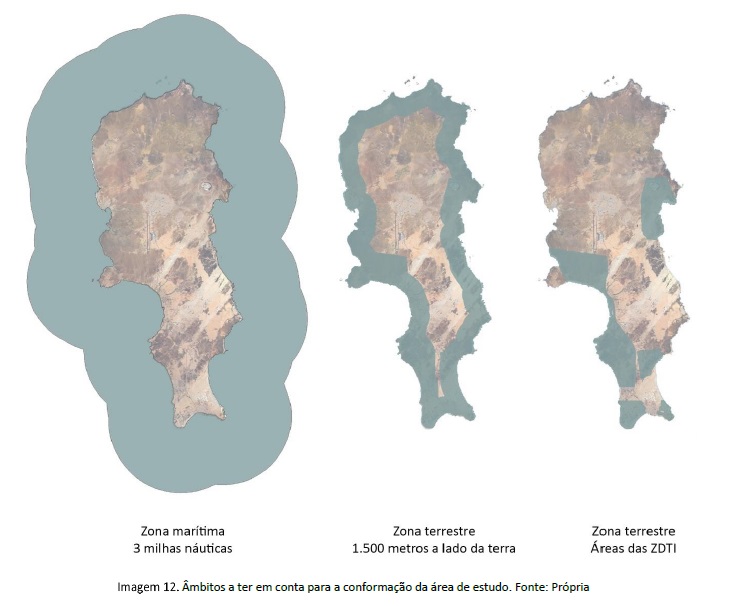
According to Article 1 of its Regulations, the plan covers a land strip of up to 1,500 metres from the high-water line and an adjacent maritime zone of up to 3 nautical miles.
The POOC_M also fully covers the Integrated Tourism Development Zones (ZDTI) and legally delimited port areas that are not included in its land zone, adjusting the limits of intervention to ensure comprehensive management.
Main objectives
Among the main objectives, described in Article 2, the following stand out: the planning of coastal zone uses; the protection of natural ecosystems in terrestrial and maritime areas against climate threats; the minimisation of risk situations for people and property in areas identified as risk zones; and the guarantee of effective public use in relation to the activities and uses proposed in the area affected by the maritime public domain, establishing safety provisions in places with the highest flow of people.
Plan content and structure
Under Article 3, the POOC_M is a set of documents, including technical reports, among others: beach and bathing sea area data sheets; communication and awareness plan. As well as characterisation, diagnosis and planning plans, which include existing site plans, protected areas, among others.
Critical area: Santa Maria Bay
Santa Maria Bay plays an important role among the most sensitive and dynamic areas of the Sal Island coastline. In the new Management Plan, it is recognised as a critical area due to the multiplicity of simultaneous activities that take place there — artisanal fishing, water sports, tourist recreation, ecosystem conservation and a large flow of visitors.

Article 12 of the Regulation is dedicated exclusively to the creation of an Integrated Management Area for this zone, with the aim of preventing conflicts between the various uses and ensuring that ecological enhancement goes hand in hand with economic and social development.
This article provides for the creation of a joint management committee, bringing together public entities with expertise in the areas of ports, the environment, tourism, sailing and fishing. This commission will seek to ensure three fundamental objectives:
• Mitigate environmental, social and economic impacts;
• Reconcile activities such as fishing and nautical recreation with the preservation of marine habitats;
• Ensure responsibility for the management of the coastal area of Santa Maria Bay by public and private initiatives..
The participation mechanisms will be regulated by specific statutes, which must be approved by the Government, and will include consultation forums, technical debate and continuous monitoring.
In addition, an assessment of the carrying capacity of Santa Maria Bay for nautical activities will be carried out, and studies on the interaction between human activities and marine species will be developed (as referred to in Article 32 of the plan) in order to achieve sustainable management.
Another essential point is the creation of an Anchorage Management Plan, an instrument that will regulate the anchoring of vessels and prevent damage to the seabed and coastal fauna, as provided for in Article 18, point 5 of the plan.
It should be noted that, until this management body is formally established, any intervention in Santa Maria Bay will depend on a favourable technical opinion from the competent authorities.
With this integrated approach, POOC_M aims for more participatory, technical and preventive territorial management, recognising that the sustainability of Santa Maria Bay depends not only on conservation, but also on how its various uses are organised.
Zones and types of use
The POOC_M Regulation also establishes a zoning system by area, in accordance with Articles 31 to 32, dividing the territory into Zone A, intended for conservation and sustainable use, and Zone B, intended for building, tourism, industrial and logistics activities. Each zone has its own usage regime, identified as dominant, compatible, conditional or incompatible, according to the attached tables.
In Zone A, the Areas of Special Natural, Landscape and Cultural Interest, regulated in Articles 35 to 39, stand out, encompassing nature reserves, monuments, protected landscapes and marine areas of high ecological value.
Special attention is given to Maritime Bathing Zones, in Articles 45 to 59. Beaches are classified into five types according to their carrying capacity and level of infrastructure, from highly equipped (Type 1, such as Santa Maria and Algodoeiro Sul beaches) to those used sporadically. Minimum requirements are defined for accessibility, cleanliness, safety, installation of equipment and waste management, in addition to the prohibition of activities incompatible with bathing, such as fishing, shellfish gathering and disorderly traffic.
Other relevant categories are Renewable Energy Development Zones (Articles 26 to 28), Preferred Zones for Aquaculture and Fishing, Articles 64 to 70, which regulate catches, licensing, closed seasons and permitted equipment; and Underwater Cultural Heritage Areas, Articles 60 to 63, which protect submerged historical and archaeological sites.
Zone B, detailed in Articles 74 to 102, covers built-up, tourist, industrial, logistics and extractive areas, all subject to specific rules on use, building, density and landscape integration, in accordance with local urban planning guidelines (PDM, EROT, POT).
From a technical point of view, POOC_M also addresses rules for sanitary infrastructure and effluent management in Articles 105 to 108, defining strict criteria for discharge pipes, treatment systems and water quality preservation, especially in bathing areas and sensitive areas.
Finally, Articles 109 to 112 deal with final provisions, including validity (the plan will remain in force for as long as it is considered necessary to protect the public interests involved and may be revised when necessary and, in any case, within a minimum period of three (3) years and a maximum of twelve (12) years after its entry into force), interinstitutional management, supervision and penalties..
The implementation of POOC_M will be coordinated between the responsible ministries, the National Institute for Land Management (INGT), the Maritime Port Institute (IMP), and the Sal Municipal Council, with the creation of a Monitoring Committee for periodic evaluation and proposed revisions whenever necessary.
The POOC_M represents a regulatory and environmental milestone for Sal Island and Cape Verde, bringing legal certainty, technical predictability, and environmental rigour. Whether for investors, tour operators, public authorities, or local communities, the POOC_M of Sal consolidates a modern and participatory approach to the management of the coastal and marine territory of Sal Island.